Pon
Wt
Śr
Czw
Pt
Sob
Ndz

The Perfect Vacation in Jerusalem and Tel Aviv Visit Israel
We welcome visitors to Israel. Many countries have a Visa Waiver Program with Israel, which allows their citizens to visit Israel without a need for a visa.
Czytaj więcej2024/04/21

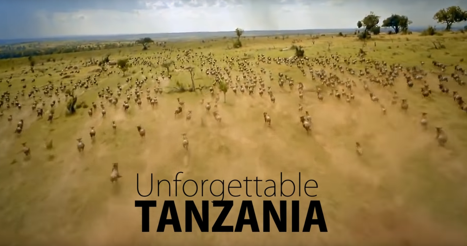
Welcome to Zimbabwe
A world of wonders! The epitome of african beauty and perfect destination for an unforgettable trip!
Czytaj więcej2024/04/20

The State of Israel Independence Day
Israel, Arabic Isrāʾīl, officially State of Israel or Hebrew Medinat Yisraʾel, country in the Middle East, located at the eastern end of the Mediterranean Sea. It is bounded to the north by Lebanon, to the northeast by Syria, to the east and southeast by Jordan, to the southwest by Egypt, and to the west by the Mediterranean Sea. Jerusalem is the seat of government and the proclaimed capital, although the latter status has not received wide international recognition. Israel is a small country with a relatively diverse topography, consisting of a lengthy coastal plain, highlands in the north and central regions, and the Negev desert in the south. Running the length of the country from north to south along its eastern border is the northern terminus of the Great Rift Valley. The State of Israel is the only Jewish nation in the modern period, and the region that now falls within its borders has a lengthy and rich history that dates from prebiblical times. The area was a part of the Roman Empire and, later, the Byzantine Empire before falling under the control of the fledgling Islamic caliphate in the 7th century ce. Although the object of dispute during the Crusades, the region, then generally known as Palestine, remained under the sway of successive Islamic dynasties until the collapse of the Ottoman Empire at the end of World War I, when it was placed under British mandate from the League of Nations. Even before the mandate, the desire for a Jewish homeland prompted a small number of Jews to immigrate to Palestine, a migration that grew dramatically during the second quarter of the 20th century with the increased persecution of Jews worldwide and subsequent Holocaust perpetrated by Nazi Germany. This vast influx of Jewish immigrants into the region, however, caused tension with the native Palestinian Arabs, and violence flared between the two groups leading up to the United Nations plan to partition Palestine into Jewish and Arab sectors and Israel’s ensuing declaration of statehood on May 14, 1948. Get a Britannica Premium subscription and gain access to exclusive content. Subscribe Now Israel fought a series of wars against neighbouring Arab states during the next 35 years, which have resulted in ongoing disputes over territory and the status of refugees. Despite continuing tensions, however, Israel concluded peace treaties with several neighbouring Arab states during the final quarter of the 20th century. Land - Relief Despite its small size, about 290 miles (470 km) north-to-south and 85 miles (135 km) east-to-west at its widest point, Israel has four geographic regions—the Mediterranean coastal plain, the hill regions of northern and central Israel, the Great Rift Valley, and the Negev—and a wide range of unique physical features and microclimates. The coastal plain is a narrow strip about 115 miles (185 km) long that widens to about 25 miles (40 km) in the south. A sandy shoreline with many beaches borders the Mediterranean coast. Inland to the east, fertile farmland is giving way to growing agricultural settlements and the cities of Tel Aviv and Haifa and their suburbs. In the north of the country, the mountains of Galilee constitute the highest part of Israel, reaching an elevation of 3,963 feet (1,208 metres) at Mount Meron (Arabic: Jebel Jarmaq). These mountains terminate to the east in an escarpment overlooking the Great Rift Valley. The mountains of Galilee are separated from the hills of the Israeli-occupied West Bank to the south by the fertile Plain of Esdraelon (Hebrew: ʿEmeq Yizreʿel), which, running approximately northwest to southeast, connects the coastal plain with the Great Rift Valley. The Mount Carmel range, which culminates in a peak 1,791 feet (546 metres) high, forms a spur reaching northwest from the highlands of the West Bank, cutting almost to the coast of Haifa. The Great Rift Valley, a long fissure in Earth’s crust, begins beyond the northern frontier of Israel and forms a series of valleys running generally south, the length of the country, to the Gulf of Aqaba. The Jordan River, which marks part of the frontier between Israel and Jordan, flows southward through the rift from Dan on Israel’s northern frontier, where it is 500 feet (152 metres) above sea level, first into the Ḥula Valley (Hebrew: ʿEmeq HaḤula), then into the freshwater Lake Tiberias, also known as the Sea of Galilee (Hebrew: Yam Kinneret), which lies 686 feet (209 metres) below sea level. The Jordan continues south along the eastern edge of the West Bank—now through the Jordan Valley (Hebrew: ʿEmeq HaYarden)—and finally into the highly saline Dead Sea, which, at 1,312 feet (400 metres) below sea level, is the lowest point of a natural landscape feature on the Earth’s surface. South of the Dead Sea, the Jordan continues through the rift, where it now forms the ʿArava Valley (Hebrew: “savannah”), an arid plain that extends to the Red Sea port of Elat. The sparsely populated Negev comprises the southern half of Israel. Arrow-shaped, this flat, sandy desert region narrows toward the south, where it becomes increasingly arid and breaks into sandstone hills cut by wadis, canyons, and cliffs before finally coming to a point where the ʿArava reaches Elat. Drainage The principal drainage system comprises Lake Tiberias and the Jordan River. Other rivers in Israel are the Yarqon, which empties into the Mediterranean near Tel Aviv; the Qishon, which runs through the western part of the Plain of Esdraelon to drain into the Mediterranean at Haifa; and a small section of the Yarmūk, a tributary of the Jordan that flows west along the Syria-Jordan border. Most of the country’s remaining streams are ephemeral and flow seasonally as wadis. The rivers are supplemented by a spring-fed underground water table that is tapped by wells. Israel has a chronic water shortage, and its hydraulic resources are fully utilized: about three-fourths for irrigation and the remainder for industrial and household water use. Soils The coastal plain is covered mainly by alluvial soils. Parts of the arid northern Negev, where soil development would not be expected, have windblown loess soils because of proximity to the coastal plain. The soils of Galilee change from calcareous rock in the coastal plain, to Cenomanian and Turonian limestone (deposited from about 99 to 89 million years ago) in Upper Galilee, and to Eocene formations (those dating from about 55 to 35 million years ago) in the lower part of the region. Rock salt and gypsum are abundant in the Great Rift Valley. The southern Negev is mainly sandstone rock with veins of granite. More … Score: https://www.britannica.com/place/Israel
Czytaj więcej2024/04/19
Discover Syria
Syria is one of the richest countries of the world with its diversity of civilizations, archeological sites, as well as its assorted nature from its desert, to its mountains, plains, sea and rivers. This is the land where great civilizational achievements, which were reached throughout the efforts and gained experiences of the human race, first saw the light.
Czytaj więcej2024/04/19

Israel in 4K
Journey with The Vine Studios through Israel. Join us on a video tour of some of the amazing sights of the Holy Land on our trip to Israel, including unique aerial views from our drone.
Czytaj więcej2024/04/18

The Republic of Zimbabwe Independence Day
Zimbabwe, officially Republic of Zimbabwe, formerly (1911–64) Southern Rhodesia, (1964–79) Rhodesia, or (1979–80) Zimbabwe Rhodesia, landlocked country of southern Africa. It shares a 125-mile (200-kilometre) border on the south with the Republic of South Africa and is bounded on the southwest and west by Botswana, on the north by Zambia, and on the northeast and east by Mozambique. The capital is Harare (formerly called Salisbury). Zimbabwe achieved majority rule and internationally recognized independence in April 1980 following a long period of colonial rule and a 15-year period of white-dominated minority rule, instituted after the minority regime’s so-called Unilateral Declaration of Independence (UDI) in 1965. The land Relief Zimbabwe lies almost entirely over 1,000 feet (300 metres) above sea level. Its principal physical feature is the broad ridge running 400 miles from southwest to northeast across the entire country, from Plumtree near the Botswana frontier through Gweru (formerly Gwelo) and Marondera (formerly Marandellas) to the Inyanga Mountains, which separate Zimbabwe from Mozambique. About 50 miles wide, this ridge ranges in altitude from 4,000 to 5,000 feet, until it eventually rises to 8,504 feet (2,592 metres) at Mount Inyangani, the highest point in Zimbabwe, in the eastern highlands. This ridge is known as the Highveld and comprises about 25 percent of the country’s total area. On each side of this central spine, sloping down northward to the Zambezi River and southward to the Limpopo River, lies the wider plateau of the Middleveld, which, at an altitude between about 3,000 and 4,000 feet, makes up roughly 40 percent of Zimbabwe’s area. Beyond this again and mostly in the south, where the Sabi, Lundi, and Nuanetsi rivers drain from the plateau into the Limpopo, lies the Lowveld, which constitutes approximately 23 percent of the country’s total area. The lowest point in Zimbabwe lies at an altitude of 660 feet near Dumela, where the Limpopo flows into Mozambique. There are no parts of Zimbabwe that can properly be called desert, although a sector northwest of Plumtree and a lengthy belt across the Lowveld in the south are severely arid. The landscape is characterized by extensive outcroppings of Precambrian rock, which is between about570 million and 4 billion years old. The most ancient part of this rock formation, known as the basement complex, covers the greater part of the country. About four-fifths of the basement complex consists of granite; the Matopo (Matopos) Hills south of the city of Bulawayo are formed from prolonged erosion of an exposed granite batholith. Some of the hills are surmounted by formations, known as balancing rocks, that have been eroded by wind and water along regular fault lines, leaving some blocks precariously balanced upon others. Elsewhere are found innumerable small rounded granite hillocks known locally as kopjes. Belts of schist in the basement complex contain the veins and lodes of most of the country’s gold, silver, and other commercial minerals. The Great Dyke, which is up to 8 miles wide and about 330 miles long, is another notable landscape feature. The longest linear mass of mafic and ultramafic rocks in the world, the Great Dyke bisects the country from north to south and contains enormous reserves of chromium, nickel, and platinum. The Alkali Ring complexes near Beitbridge in the Sabi valley are distinctive igneous intrusions. The Karoo (Karroo) System—a thick layer of sedimentary rocks consisting of shale, sandstone, and grit of Permian and Triassic age (about 200 to 300 million years old)—covers the Zambezi valley and the valleys of its tributaries from Hwange (formerly Wankie) southward to Bulawayo and spreads across parts of the southern Lowveld from Tuli, near the southern border, to the Sabi River. Get a Britannica Premium subscription and gain access to exclusive content. Subscribe Now Drainage and soils Major faulting from southwest to northeast formed the middle Zambezi trough, which is now partially flooded by the Lake Kariba reservoir. Other faulting episodes affected the depressions of the Sabi (Save) and Limpopo rivers. Except for a small area of internal drainage in the dry southwest, these three rivers carry the entire runoff of the country to the Indian Ocean via Mozambique. The central ridgeline of the Highveld is the major divide separating Zambezi from Limpopo-Sabi drainage. The light, sandy soils found in most parts of Zimbabwe are residual soils developed largely from the granite parent material. They are highly weathered and leached, even in the areas of lower rainfall, and do not easily retain water because of their coarse texture. Outcrops of basement schists give rise to rich red clays and loams—some of the country’s best soils—but their extent is limited. Since most rain occurs in heavy showers during a few months of the year, rapid runoff and high rates of erosion are common. The meagre mineral reserves in most soils imply an inherently low fertility; under cultivation, productivity drops rapidly after a few years. The difficulty of cultivating these lighter soils is greatest in the Black farming areas, where population pressure no longer allows land to be temporarily abandoned to rejuvenate after cultivation; Black farmers, because of a lack of capital, are also less able than white farmers to maintain the mineral fertility with manure and chemical fertilizers. Climate of Zimbabwe Zimbabwe, lying north of the Tropic of Capricorn, is completely within the tropics but enjoys subtropical conditions because of its high average elevation. Toward the end of the hot, dry months, which last from August to October, monsoon winds that have crossed the Indian Ocean and Mozambique result in intense orographic rainfall when they meet the rampart formed by the eastern highlands. The eastern regions consequently receive the country’s heaviest rainfall and have a more prolonged rainy season (lasting from October into April) than the rest of Zimbabwe. The high altitude of the broad plateau of western Zimbabwe helps to guarantee fine weather there during the cool, dry winter months from May to August. June is generally the coolest month and October the warmest; temperature variations correspond closely to altitude. Inyanga, at about 5,500 feet in the eastern highlands, varies in temperature from a mean of 52° F (11° C) in July to one of 65° F (18° C) in October. Harare, at about 4,800 feet, has seasonal temperatures varying from 57° F (14° C) to 70° F (21° C), and Bulawayo, at 4,400 feet, varies from 57° F (14° C) to 70° F (21° C). Daily variations about these means are some 13° F (7° C) warmer in the afternoon and 13° F (7° C) cooler at night. Harare and Bulawayo each average about eight hours of sunshine per day, and this average does not drop below six hours during the rainy season. More …. Score: https://www.britannica.com/place/Zimbabwe
Czytaj więcej2024/04/18


Filmy promujące
Promuj regiony
Promocja regionów obejmie swoim zasięgiem zarówno region, Polskę, jak i świat. Zaplanowane działania promocyjne pozwolą dotrzeć do mieszkańców regionu - potencjalnych konsumentów oraz inwestorów w kraju i za granicą.
Panama 2019 | 4K | must see places | travel guide
A clip of our Panama trip in april 2019. The journey was planned as followed: We arrived in Panama City and took the Night Bus to Almirante to get to 0:41 Bocas del Torro
Bethlehem, Palestine: Church of the Nativity
More info about Rick's travels to Palestine: http://www.ricksteves.com/watch-read-... No longer just the little town of Christmas-carol fame, Bethlehem is a leading Palestinian city. Its skyline is a commotion of both crescents and crosses — a reminder that the town, while now mostly Muslim, still has many Christians.

Lokalna Grupa Działania - Forum Powiatu Garwolińskiego

Nous vous invitons a coopérer

O programie Erasmus+

We invite you to cooperate

Zapisz się do biuletynu dyplomatycznego