Wydarzenia Święta narodowe Przydatne Linki Film promujący Odwiedź nas i poznaj Kontakt
Cuba Travel | Tourism Portal

Cuba Travel has the best tourist guide for your trips to Cuba. Find tourist destinations, attractions, facts and all the right info for your Cuban vacation.

Anniversary of the Revolution. Republic of Cuba

Cuba, country of the West Indies, the largest single island of the archipelago, and one of the more-influential states of the Caribbean region. The domain of the Arawakan-speaking Taino, who had displaced even earlier inhabitants, Cuba was claimed by Christopher Columbus for Spain in 1492. It became the Spanish empire’s most-important source of raw sugar in the 18th century and later earned the sobriquet “Pearl of the Antilles.” Though Spain had to fight several difficult and costly campaigns against independence movements, it retained rule of Cuba until 1898, when it was defeated by the United States and Cuban forces in the Spanish-American War. Cuba soon gained formal independence, though it remained overshadowed by the nearby United States. On New Year’s Day, 1959, revolutionary forces led by Fidel Castro overthrew the government of dictator Fulgencio Batista. Two years later Castro proclaimed the Marxist-Leninist nature of the revolution. Cuba became economically isolated from its northern neighbour as it developed close links to the Soviet Union. However, the collapse of the Soviet Union in the early 1990s isolated Cuba still further, bringing on what Cubans euphemistically call the período especial (“special period”), a time of widespread shortages and financial uncertainty. By the early 21st century, Cuba had loosened some of its more-restrictive economic and social policies, but the United States continued its decades-long economic embargo against the Castro regime, though the December 2014 announcement of the resumption of diplomatic relations between the two countries held promise of the embargo’s removal. Life in contemporary Cuba is thus challenging, given the limited access to food, transportation, electrical power, and other necessities. Even so, many Cubans show a fierce pride in their revolutionary society, the only one of its kind in Latin America. The protagonist of anthropologist Miguel Barnet’s novel Canción de Rachel (1969; Rachel’s Song, 1991) describes it thus: This island is something special. The strangest, most tragic things have happened here. And it will always be that way. The earth, like humankind, has its destiny. And Cuba’s is a mysterious destiny. Cuba is a multicultural, largely urban nation, although it has only one major city: Havana (La Habana), the capital and commercial hub of the country, on the northwestern coast. Handsome if rather run-down, Havana has a scenic waterfront and is surrounded by fine beaches, an attraction for increasing numbers of visitors from abroad. Cuba’s other cities—including Santiago, Camagüey, Holguín, and, especially, Trinidad—offer a rich legacy of colonial Spanish architecture to complement contemporary buildings. Land Cuba is situated just south of the Tropic of Cancer at the intersection of the Atlantic Ocean (north and east), the Gulf of Mexico (west), and the Caribbean Sea (south). Haiti, the nearest neighbouring country, is 48 miles (77 km) to the east, across the Windward Passage; Jamaica is 87 miles (140 km) to the south; the Bahamas archipelago extends to within 50 miles (80 km) of the northern coast; and the United States is about 90 miles (150 km) to the north across the Straits of Florida. The country comprises an archipelago of about 1,600 islands, islets, and cays with a combined area three-fourths as large as the U.S. state of Florida. The islands form an important segment of the Antilles (West Indies) island chain, which continues east and then south in a great arc enclosing the Caribbean Sea. The island of Cuba itself is by far the largest in the chain and constitutes one of the four islands of the Greater Antilles. In general, the island runs from northwest to southeast and is long and narrow—777 miles (1,250 km) long and 119 miles (191 km) across at its widest and 19 miles (31 km) at its narrowest point. Relief Groups of mountains and hills cover about one-fourth of the island of Cuba. The most rugged range is the Sierra Maestra, which stretches approximately 150 miles (240 km) along the southeastern coast and reaches the island’s highest elevations—6,476 feet (1,974 metres) at Turquino Peak and 5,676 feet (1,730 metres) at Bayamesa Peak. Near the centre of the island are the Santa Clara Highlands, the Sierra de Escambray (Guamuhaya), and the Sierra de Trinidad. The Cordillera de Guaniguanico in the far west stretches from southwest to northeast for 110 miles (180 km) and comprises the Sierra de los Órganos and the Sierra del Rosario, the latter attaining 2,270 feet (692 metres) at Guajaibón Peak. Much of central-western Cuba is punctuated by spectacularly shaped, vegetation-clad hillocks called mogotes. Serpentine highlands distinguish northern and central La Habana and Matanzas provinces, as well as the central parts of Camagüey and Las Tunas. The plains covering about two-thirds of the main island have been used extensively for sugarcane and tobacco cultivation and livestock raising. The coastal basins of Santiago de Cuba and Guantánamo and the extensive Cauto River valley lie in the southeast. The Cauto lowland adjoins a series of coastal plains that continue across the island from east to west, including the Southern Plain, Júcaro-Morón Plain, Zapata Peninsula (Zapata Swamp), Southern Karst and Colón Plain, and Southern Alluvial Plain. Cuba’s most extensive swamps cover the Zapata Peninsula and surround the Bay of Pigs (Bahía de Cochinos). The Las Villas Plain of the North, Las Villas Plain of the Northeast, and Northern Plain stretch across much of the opposite coast. Cuba’s approximately 3,570 miles (5,745 km) of irregular, picturesque coastline are characterized by many bays, sandy beaches, mangrove swamps, coral reefs, and rugged cliffs. There are also some spectacular caverns in the interior, notably the 16-mile- (26-km-) long Cave of Santo Tomás in the Sierra Quemado of western Cuba. The main island is surrounded by a submerged platform covering an additional 30,000 square miles (78,000 square km). Among the extensive cays and archipelagoes ringing the main island are Los Colorados, to the northwest; Sabana and Camagüey, both off the north-central coast; the Jardines de la Reina (“Queen’s Gardens”), near the south-central coast; and Canarreos, near the southwest coast. Juventud Island (Isla de la Juventud; “Isle of Youth”), formerly called Pinos Island (Isla de los Pinos; “Isle of Pines”), is the second largest of the Cuban islands, covering 850 square miles (2,200 square km). It is technically a part of the Canarreos Archipelago. Hills, dotted with groves of pine and palm, characterize much of the island’s northwest and southeast. Sand and clay plains cover parts of the north, a gravel bed takes up most of the southern part of the island, and bogs dominate the coasts and sparsely inhabited interior. Drainage Cuban rivers are generally short, with meagre flow; of the nearly 600 rivers and streams, two-fifths discharge to the north, the remainder to the south. The Zapata Peninsula is the most extensive of Cuba’s many coastal wetlands. The main island’s heaviest precipitation and largest rivers are in the southeast, where the Cauto, at 230 miles (370 km) the country’s longest river, lies between the Sierra Maestra and the smaller Sierra del Cristal. The Cauto and its tributaries, notably the Salado, drain the Sierra Maestra and lesser uplands in the provinces of Holguín and Las Tunas. Other rivers in this region include the Guantánamo, Sagua de Tánamo, Toa, and Mayarí. To the west the most important southward-flowing rivers are the Sevilla, Najasa, San Pedro, Jatibonico del Sur, Zaza, Agabama, Arimao, Hondo, and Cuyaguateje. Northward-flowing rivers include the Saramaguacán, Caonao, Sagua la Grande, and La Palma. Cuban lakes are small and more properly classified as freshwater or saltwater lagoons. The latter include Leche (“Milk”) Lagoon, which has a surface area of 26 square miles (67 square km). It is technically a sound because several natural channels connect it to the Atlantic Ocean. Sea movements generate disturbances in the calcium carbonate deposits at the bottom of the lake to produce the milky appearance of its waters. Soils of Cuba The complicated Cuban topography and geology have produced at least 13 distinct groups of soils, the majority of which are fertile and cultivated throughout the year. Highly fertile red limestone soil extends from west of Havana to near Cienfuegos on the southern coast and lies in extensive patches in western Camagüey province, providing the basis for Cuba’s main agricultural output. Another area of fertile soil is north of Cienfuegos between the Sierra de Sancti Spíritus and the Caribbean coast. Camagüey province and the Guantánamo basin have some arable land, although of lower fertility. Areas of sandy soil in Pinar del Río, Villa Clara, and portions of Ciego de Ávila and Camagüey provinces cannot hold moisture and are marginally fertile, as are the soils of the mangrove-dotted coastal swamps and cays. Climate Cuba lies in the tropics. Because it is located on the southwestern periphery of the North Atlantic high atmospheric pressure zone, its climate is influenced by the northeast trade winds in winter and by east-northeast winds in summer. The warm currents that form the Gulf Stream have a moderating influence along the coasts. The annual mean temperature is 79 °F (26 °C), with little variation between January, the coolest month, at 73 °F (23 °C) and August, the warmest month, at 82 °F (28 °C). The November–April dry season abruptly changes to the May–October rainy season. Annual precipitation averages 54 inches (1,380 mm). From June to November the country is often exposed to hurricanes, whose strong winds and heavy rains can cause widespread damage and suffering. More …. Source:  https://www.britannica.com/place/Cuba

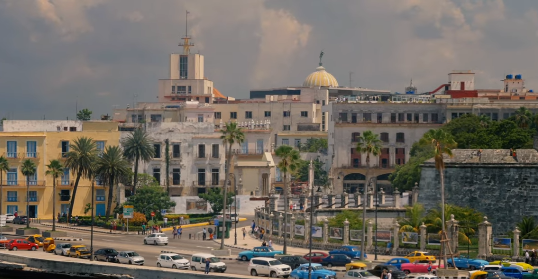
Havana City Tour - Travel Video (La Habana, Cuba)

Havana is the number one attraction for travelers to Cuba, and it's little wonder! Old squares and aged buildings sit alongside colonial palaces, impressive avenues and idyllic white-sand beaches in this vibrant Caribbean city.

Cuba Travel | Tourism Portal

Cuba Travel has the best tourist guide for your trips to Cuba. Find tourist destinations, attractions, facts and all the right info for your Cuban vacation.

Anniversary of the Revolution. Republic of Cuba

Cuba, country of the West Indies, the largest single island of the archipelago, and one of the more-influential states of the Caribbean region. The domain of the Arawakan-speaking Taino, who had displaced even earlier inhabitants, Cuba was claimed by Christopher Columbus for Spain in 1492. It became the Spanish empire’s most-important source of raw sugar in the 18th century and later earned the sobriquet “Pearl of the Antilles.” Though Spain had to fight several difficult and costly campaigns against independence movements, it retained rule of Cuba until 1898, when it was defeated by the United States and Cuban forces in the Spanish-American War. Cuba soon gained formal independence, though it remained overshadowed by the nearby United States. On New Year’s Day, 1959, revolutionary forces led by Fidel Castro overthrew the government of dictator Fulgencio Batista. Two years later Castro proclaimed the Marxist-Leninist nature of the revolution. Cuba became economically isolated from its northern neighbour as it developed close links to the Soviet Union. However, the collapse of the Soviet Union in the early 1990s isolated Cuba still further, bringing on what Cubans euphemistically call the período especial (“special period”), a time of widespread shortages and financial uncertainty. By the early 21st century, Cuba had loosened some of its more-restrictive economic and social policies, but the United States continued its decades-long economic embargo against the Castro regime, though the December 2014 announcement of the resumption of diplomatic relations between the two countries held promise of the embargo’s removal. Life in contemporary Cuba is thus challenging, given the limited access to food, transportation, electrical power, and other necessities. Even so, many Cubans show a fierce pride in their revolutionary society, the only one of its kind in Latin America. The protagonist of anthropologist Miguel Barnet’s novel Canción de Rachel (1969; Rachel’s Song, 1991) describes it thus: This island is something special. The strangest, most tragic things have happened here. And it will always be that way. The earth, like humankind, has its destiny. And Cuba’s is a mysterious destiny. Cuba is a multicultural, largely urban nation, although it has only one major city: Havana (La Habana), the capital and commercial hub of the country, on the northwestern coast. Handsome if rather run-down, Havana has a scenic waterfront and is surrounded by fine beaches, an attraction for increasing numbers of visitors from abroad. Cuba’s other cities—including Santiago, Camagüey, Holguín, and, especially, Trinidad—offer a rich legacy of colonial Spanish architecture to complement contemporary buildings. Land Cuba is situated just south of the Tropic of Cancer at the intersection of the Atlantic Ocean (north and east), the Gulf of Mexico (west), and the Caribbean Sea (south). Haiti, the nearest neighbouring country, is 48 miles (77 km) to the east, across the Windward Passage; Jamaica is 87 miles (140 km) to the south; the Bahamas archipelago extends to within 50 miles (80 km) of the northern coast; and the United States is about 90 miles (150 km) to the north across the Straits of Florida. The country comprises an archipelago of about 1,600 islands, islets, and cays with a combined area three-fourths as large as the U.S. state of Florida. The islands form an important segment of the Antilles (West Indies) island chain, which continues east and then south in a great arc enclosing the Caribbean Sea. The island of Cuba itself is by far the largest in the chain and constitutes one of the four islands of the Greater Antilles. In general, the island runs from northwest to southeast and is long and narrow—777 miles (1,250 km) long and 119 miles (191 km) across at its widest and 19 miles (31 km) at its narrowest point. Relief Groups of mountains and hills cover about one-fourth of the island of Cuba. The most rugged range is the Sierra Maestra, which stretches approximately 150 miles (240 km) along the southeastern coast and reaches the island’s highest elevations—6,476 feet (1,974 metres) at Turquino Peak and 5,676 feet (1,730 metres) at Bayamesa Peak. Near the centre of the island are the Santa Clara Highlands, the Sierra de Escambray (Guamuhaya), and the Sierra de Trinidad. The Cordillera de Guaniguanico in the far west stretches from southwest to northeast for 110 miles (180 km) and comprises the Sierra de los Órganos and the Sierra del Rosario, the latter attaining 2,270 feet (692 metres) at Guajaibón Peak. Much of central-western Cuba is punctuated by spectacularly shaped, vegetation-clad hillocks called mogotes. Serpentine highlands distinguish northern and central La Habana and Matanzas provinces, as well as the central parts of Camagüey and Las Tunas. The plains covering about two-thirds of the main island have been used extensively for sugarcane and tobacco cultivation and livestock raising. The coastal basins of Santiago de Cuba and Guantánamo and the extensive Cauto River valley lie in the southeast. The Cauto lowland adjoins a series of coastal plains that continue across the island from east to west, including the Southern Plain, Júcaro-Morón Plain, Zapata Peninsula (Zapata Swamp), Southern Karst and Colón Plain, and Southern Alluvial Plain. Cuba’s most extensive swamps cover the Zapata Peninsula and surround the Bay of Pigs (Bahía de Cochinos). The Las Villas Plain of the North, Las Villas Plain of the Northeast, and Northern Plain stretch across much of the opposite coast. Cuba’s approximately 3,570 miles (5,745 km) of irregular, picturesque coastline are characterized by many bays, sandy beaches, mangrove swamps, coral reefs, and rugged cliffs. There are also some spectacular caverns in the interior, notably the 16-mile- (26-km-) long Cave of Santo Tomás in the Sierra Quemado of western Cuba. The main island is surrounded by a submerged platform covering an additional 30,000 square miles (78,000 square km). Among the extensive cays and archipelagoes ringing the main island are Los Colorados, to the northwest; Sabana and Camagüey, both off the north-central coast; the Jardines de la Reina (“Queen’s Gardens”), near the south-central coast; and Canarreos, near the southwest coast. Juventud Island (Isla de la Juventud; “Isle of Youth”), formerly called Pinos Island (Isla de los Pinos; “Isle of Pines”), is the second largest of the Cuban islands, covering 850 square miles (2,200 square km). It is technically a part of the Canarreos Archipelago. Hills, dotted with groves of pine and palm, characterize much of the island’s northwest and southeast. Sand and clay plains cover parts of the north, a gravel bed takes up most of the southern part of the island, and bogs dominate the coasts and sparsely inhabited interior. Drainage Cuban rivers are generally short, with meagre flow; of the nearly 600 rivers and streams, two-fifths discharge to the north, the remainder to the south. The Zapata Peninsula is the most extensive of Cuba’s many coastal wetlands. The main island’s heaviest precipitation and largest rivers are in the southeast, where the Cauto, at 230 miles (370 km) the country’s longest river, lies between the Sierra Maestra and the smaller Sierra del Cristal. The Cauto and its tributaries, notably the Salado, drain the Sierra Maestra and lesser uplands in the provinces of Holguín and Las Tunas. Other rivers in this region include the Guantánamo, Sagua de Tánamo, Toa, and Mayarí. To the west the most important southward-flowing rivers are the Sevilla, Najasa, San Pedro, Jatibonico del Sur, Zaza, Agabama, Arimao, Hondo, and Cuyaguateje. Northward-flowing rivers include the Saramaguacán, Caonao, Sagua la Grande, and La Palma. Cuban lakes are small and more properly classified as freshwater or saltwater lagoons. The latter include Leche (“Milk”) Lagoon, which has a surface area of 26 square miles (67 square km). It is technically a sound because several natural channels connect it to the Atlantic Ocean. Sea movements generate disturbances in the calcium carbonate deposits at the bottom of the lake to produce the milky appearance of its waters. Soils of Cuba The complicated Cuban topography and geology have produced at least 13 distinct groups of soils, the majority of which are fertile and cultivated throughout the year. Highly fertile red limestone soil extends from west of Havana to near Cienfuegos on the southern coast and lies in extensive patches in western Camagüey province, providing the basis for Cuba’s main agricultural output. Another area of fertile soil is north of Cienfuegos between the Sierra de Sancti Spíritus and the Caribbean coast. Camagüey province and the Guantánamo basin have some arable land, although of lower fertility. Areas of sandy soil in Pinar del Río, Villa Clara, and portions of Ciego de Ávila and Camagüey provinces cannot hold moisture and are marginally fertile, as are the soils of the mangrove-dotted coastal swamps and cays. Climate Cuba lies in the tropics. Because it is located on the southwestern periphery of the North Atlantic high atmospheric pressure zone, its climate is influenced by the northeast trade winds in winter and by east-northeast winds in summer. The warm currents that form the Gulf Stream have a moderating influence along the coasts. The annual mean temperature is 79 °F (26 °C), with little variation between January, the coolest month, at 73 °F (23 °C) and August, the warmest month, at 82 °F (28 °C). The November–April dry season abruptly changes to the May–October rainy season. Annual precipitation averages 54 inches (1,380 mm). From June to November the country is often exposed to hurricanes, whose strong winds and heavy rains can cause widespread damage and suffering. More …. Source:  https://www.britannica.com/place/Cuba

Havana City Tour - Travel Video (La Habana, Cuba)

Havana is the number one attraction for travelers to Cuba, and it's little wonder! Old squares and aged buildings sit alongside colonial palaces, impressive avenues and idyllic white-sand beaches in this vibrant Caribbean city.

Cuba Travel | Tourism Portal

Cuba Travel has the best tourist guide for your trips to Cuba. Find tourist destinations, attractions, facts and all the right info for your Cuban vacation.

Anniversary of the Revolution. Republic of Cuba

Cuba, country of the West Indies, the largest single island of the archipelago, and one of the more-influential states of the Caribbean region. The domain of the Arawakan-speaking Taino, who had displaced even earlier inhabitants, Cuba was claimed by Christopher Columbus for Spain in 1492. It became the Spanish empire’s most-important source of raw sugar in the 18th century and later earned the sobriquet “Pearl of the Antilles.” Though Spain had to fight several difficult and costly campaigns against independence movements, it retained rule of Cuba until 1898, when it was defeated by the United States and Cuban forces in the Spanish-American War. Cuba soon gained formal independence, though it remained overshadowed by the nearby United States. On New Year’s Day, 1959, revolutionary forces led by Fidel Castro overthrew the government of dictator Fulgencio Batista. Two years later Castro proclaimed the Marxist-Leninist nature of the revolution. Cuba became economically isolated from its northern neighbour as it developed close links to the Soviet Union. However, the collapse of the Soviet Union in the early 1990s isolated Cuba still further, bringing on what Cubans euphemistically call the período especial (“special period”), a time of widespread shortages and financial uncertainty. By the early 21st century, Cuba had loosened some of its more-restrictive economic and social policies, but the United States continued its decades-long economic embargo against the Castro regime, though the December 2014 announcement of the resumption of diplomatic relations between the two countries held promise of the embargo’s removal. Life in contemporary Cuba is thus challenging, given the limited access to food, transportation, electrical power, and other necessities. Even so, many Cubans show a fierce pride in their revolutionary society, the only one of its kind in Latin America. The protagonist of anthropologist Miguel Barnet’s novel Canción de Rachel (1969; Rachel’s Song, 1991) describes it thus: This island is something special. The strangest, most tragic things have happened here. And it will always be that way. The earth, like humankind, has its destiny. And Cuba’s is a mysterious destiny. Cuba is a multicultural, largely urban nation, although it has only one major city: Havana (La Habana), the capital and commercial hub of the country, on the northwestern coast. Handsome if rather run-down, Havana has a scenic waterfront and is surrounded by fine beaches, an attraction for increasing numbers of visitors from abroad. Cuba’s other cities—including Santiago, Camagüey, Holguín, and, especially, Trinidad—offer a rich legacy of colonial Spanish architecture to complement contemporary buildings. Land Cuba is situated just south of the Tropic of Cancer at the intersection of the Atlantic Ocean (north and east), the Gulf of Mexico (west), and the Caribbean Sea (south). Haiti, the nearest neighbouring country, is 48 miles (77 km) to the east, across the Windward Passage; Jamaica is 87 miles (140 km) to the south; the Bahamas archipelago extends to within 50 miles (80 km) of the northern coast; and the United States is about 90 miles (150 km) to the north across the Straits of Florida. The country comprises an archipelago of about 1,600 islands, islets, and cays with a combined area three-fourths as large as the U.S. state of Florida. The islands form an important segment of the Antilles (West Indies) island chain, which continues east and then south in a great arc enclosing the Caribbean Sea. The island of Cuba itself is by far the largest in the chain and constitutes one of the four islands of the Greater Antilles. In general, the island runs from northwest to southeast and is long and narrow—777 miles (1,250 km) long and 119 miles (191 km) across at its widest and 19 miles (31 km) at its narrowest point. Relief Groups of mountains and hills cover about one-fourth of the island of Cuba. The most rugged range is the Sierra Maestra, which stretches approximately 150 miles (240 km) along the southeastern coast and reaches the island’s highest elevations—6,476 feet (1,974 metres) at Turquino Peak and 5,676 feet (1,730 metres) at Bayamesa Peak. Near the centre of the island are the Santa Clara Highlands, the Sierra de Escambray (Guamuhaya), and the Sierra de Trinidad. The Cordillera de Guaniguanico in the far west stretches from southwest to northeast for 110 miles (180 km) and comprises the Sierra de los Órganos and the Sierra del Rosario, the latter attaining 2,270 feet (692 metres) at Guajaibón Peak. Much of central-western Cuba is punctuated by spectacularly shaped, vegetation-clad hillocks called mogotes. Serpentine highlands distinguish northern and central La Habana and Matanzas provinces, as well as the central parts of Camagüey and Las Tunas. The plains covering about two-thirds of the main island have been used extensively for sugarcane and tobacco cultivation and livestock raising. The coastal basins of Santiago de Cuba and Guantánamo and the extensive Cauto River valley lie in the southeast. The Cauto lowland adjoins a series of coastal plains that continue across the island from east to west, including the Southern Plain, Júcaro-Morón Plain, Zapata Peninsula (Zapata Swamp), Southern Karst and Colón Plain, and Southern Alluvial Plain. Cuba’s most extensive swamps cover the Zapata Peninsula and surround the Bay of Pigs (Bahía de Cochinos). The Las Villas Plain of the North, Las Villas Plain of the Northeast, and Northern Plain stretch across much of the opposite coast. Cuba’s approximately 3,570 miles (5,745 km) of irregular, picturesque coastline are characterized by many bays, sandy beaches, mangrove swamps, coral reefs, and rugged cliffs. There are also some spectacular caverns in the interior, notably the 16-mile- (26-km-) long Cave of Santo Tomás in the Sierra Quemado of western Cuba. The main island is surrounded by a submerged platform covering an additional 30,000 square miles (78,000 square km). Among the extensive cays and archipelagoes ringing the main island are Los Colorados, to the northwest; Sabana and Camagüey, both off the north-central coast; the Jardines de la Reina (“Queen’s Gardens”), near the south-central coast; and Canarreos, near the southwest coast. Juventud Island (Isla de la Juventud; “Isle of Youth”), formerly called Pinos Island (Isla de los Pinos; “Isle of Pines”), is the second largest of the Cuban islands, covering 850 square miles (2,200 square km). It is technically a part of the Canarreos Archipelago. Hills, dotted with groves of pine and palm, characterize much of the island’s northwest and southeast. Sand and clay plains cover parts of the north, a gravel bed takes up most of the southern part of the island, and bogs dominate the coasts and sparsely inhabited interior. Drainage Cuban rivers are generally short, with meagre flow; of the nearly 600 rivers and streams, two-fifths discharge to the north, the remainder to the south. The Zapata Peninsula is the most extensive of Cuba’s many coastal wetlands. The main island’s heaviest precipitation and largest rivers are in the southeast, where the Cauto, at 230 miles (370 km) the country’s longest river, lies between the Sierra Maestra and the smaller Sierra del Cristal. The Cauto and its tributaries, notably the Salado, drain the Sierra Maestra and lesser uplands in the provinces of Holguín and Las Tunas. Other rivers in this region include the Guantánamo, Sagua de Tánamo, Toa, and Mayarí. To the west the most important southward-flowing rivers are the Sevilla, Najasa, San Pedro, Jatibonico del Sur, Zaza, Agabama, Arimao, Hondo, and Cuyaguateje. Northward-flowing rivers include the Saramaguacán, Caonao, Sagua la Grande, and La Palma. Cuban lakes are small and more properly classified as freshwater or saltwater lagoons. The latter include Leche (“Milk”) Lagoon, which has a surface area of 26 square miles (67 square km). It is technically a sound because several natural channels connect it to the Atlantic Ocean. Sea movements generate disturbances in the calcium carbonate deposits at the bottom of the lake to produce the milky appearance of its waters. Soils of Cuba The complicated Cuban topography and geology have produced at least 13 distinct groups of soils, the majority of which are fertile and cultivated throughout the year. Highly fertile red limestone soil extends from west of Havana to near Cienfuegos on the southern coast and lies in extensive patches in western Camagüey province, providing the basis for Cuba’s main agricultural output. Another area of fertile soil is north of Cienfuegos between the Sierra de Sancti Spíritus and the Caribbean coast. Camagüey province and the Guantánamo basin have some arable land, although of lower fertility. Areas of sandy soil in Pinar del Río, Villa Clara, and portions of Ciego de Ávila and Camagüey provinces cannot hold moisture and are marginally fertile, as are the soils of the mangrove-dotted coastal swamps and cays. Climate Cuba lies in the tropics. Because it is located on the southwestern periphery of the North Atlantic high atmospheric pressure zone, its climate is influenced by the northeast trade winds in winter and by east-northeast winds in summer. The warm currents that form the Gulf Stream have a moderating influence along the coasts. The annual mean temperature is 79 °F (26 °C), with little variation between January, the coolest month, at 73 °F (23 °C) and August, the warmest month, at 82 °F (28 °C). The November–April dry season abruptly changes to the May–October rainy season. Annual precipitation averages 54 inches (1,380 mm). From June to November the country is often exposed to hurricanes, whose strong winds and heavy rains can cause widespread damage and suffering. More …. Source:  https://www.britannica.com/place/Cuba

Havana City Tour - Travel Video (La Habana, Cuba)

Havana is the number one attraction for travelers to Cuba, and it's little wonder! Old squares and aged buildings sit alongside colonial palaces, impressive avenues and idyllic white-sand beaches in this vibrant Caribbean city.

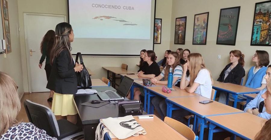
Conferencia sobre Cuba en el Liceo Stefan Zeromski, en Varsovia

Como parte de la estrategia de fortalecimiento de las relaciones con los centros educativos en Polonia y la promoción del conocimiento sobre Cuba en los mismos, la embajadora Margarita Valle y la tercera secretaria de la Embajada de Cuba ofrecieron una conferencia en el Liceo Zeromski. Se expusieron las afectaciones económicas que provoca el bloqueo y el impacto real de esta política en la vida de los cubanos. Se disfrutó de canciones cubanas como la Guantanamera que sirvió de base para hablar de nuestro Héroe Nacional José Martí y la ilegal Base Naval de Guantánamo.

La leyenda de la música cubana Omara Portuondo actuará nuevamente en Polonia

La legendaria diva y cantante de Buena Vista Social Club, actuará el 19 de junio de 2023, como parte de la última gira mundial, en el Foro Nacional de la Música de Wrocław, Polonia. Nacida en La Habana, Omara Portuondo ha estado en el escenario durante más de 70 años y es la última de las figuras vivas e importantes del Buena Vista Social Club. Esta talentosa artista debutó con el álbum Magia negra (1959) que combina música cubana y jazz. El momento decisivo en su carrera fue en 1996, cuando fue invitada a participar en las sesiones de grabación del Buena Vista Social Club (para World Circuit).

HAVANA CITY TOUR - TRAVEL VIDEO (LA HABANA, CUBA)

Havana is the number one attraction for travelers to Cuba, and it's little wonder! Old squares and aged buildings sit alongside colonial palaces, impressive avenues and idyllic white-sand beaches in this vibrant Caribbean city.

Anniversary of the Revolution. Republic of Cuba

Cuba, country of the West Indies, the largest single island of the archipelago, and one of the more-influential states of the Caribbean region. The domain of the Arawakan-speaking Taino, who had displaced even earlier inhabitants, Cuba was claimed by Christopher Columbus for Spain in 1492. It became the Spanish empire’s most-important source of raw sugar in the 18th century and later earned the sobriquet “Pearl of the Antilles.” Though Spain had to fight several difficult and costly campaigns against independence movements, it retained rule of Cuba until 1898, when it was defeated by the United States and Cuban forces in the Spanish-American War. Cuba soon gained formal independence, though it remained overshadowed by the nearby United States. On New Year’s Day, 1959, revolutionary forces led by Fidel Castro overthrew the government of dictator Fulgencio Batista. Two years later Castro proclaimed the Marxist-Leninist nature of the revolution. Cuba became economically isolated from its northern neighbour as it developed close links to the Soviet Union. However, the collapse of the Soviet Union in the early 1990s isolated Cuba still further, bringing on what Cubans euphemistically call the período especial (“special period”), a time of widespread shortages and financial uncertainty. By the early 21st century, Cuba had loosened some of its more-restrictive economic and social policies, but the United States continued its decades-long economic embargo against the Castro regime, though the December 2014 announcement of the resumption of diplomatic relations between the two countries held promise of the embargo’s removal. Life in contemporary Cuba is thus challenging, given the limited access to food, transportation, electrical power, and other necessities. Even so, many Cubans show a fierce pride in their revolutionary society, the only one of its kind in Latin America. The protagonist of anthropologist Miguel Barnet’s novel Canción de Rachel (1969; Rachel’s Song, 1991) describes it thus: This island is something special. The strangest, most tragic things have happened here. And it will always be that way. The earth, like humankind, has its destiny. And Cuba’s is a mysterious destiny. Cuba is a multicultural, largely urban nation, although it has only one major city: Havana (La Habana), the capital and commercial hub of the country, on the northwestern coast. Handsome if rather run-down, Havana has a scenic waterfront and is surrounded by fine beaches, an attraction for increasing numbers of visitors from abroad. Cuba’s other cities—including Santiago, Camagüey, Holguín, and, especially, Trinidad—offer a rich legacy of colonial Spanish architecture to complement contemporary buildings. Land Cuba is situated just south of the Tropic of Cancer at the intersection of the Atlantic Ocean (north and east), the Gulf of Mexico (west), and the Caribbean Sea (south). Haiti, the nearest neighbouring country, is 48 miles (77 km) to the east, across the Windward Passage; Jamaica is 87 miles (140 km) to the south; the Bahamas archipelago extends to within 50 miles (80 km) of the northern coast; and the United States is about 90 miles (150 km) to the north across the Straits of Florida. The country comprises an archipelago of about 1,600 islands, islets, and cays with a combined area three-fourths as large as the U.S. state of Florida. The islands form an important segment of the Antilles (West Indies) island chain, which continues east and then south in a great arc enclosing the Caribbean Sea. The island of Cuba itself is by far the largest in the chain and constitutes one of the four islands of the Greater Antilles. In general, the island runs from northwest to southeast and is long and narrow—777 miles (1,250 km) long and 119 miles (191 km) across at its widest and 19 miles (31 km) at its narrowest point. Relief Groups of mountains and hills cover about one-fourth of the island of Cuba. The most rugged range is the Sierra Maestra, which stretches approximately 150 miles (240 km) along the southeastern coast and reaches the island’s highest elevations—6,476 feet (1,974 metres) at Turquino Peak and 5,676 feet (1,730 metres) at Bayamesa Peak. Near the centre of the island are the Santa Clara Highlands, the Sierra de Escambray (Guamuhaya), and the Sierra de Trinidad. The Cordillera de Guaniguanico in the far west stretches from southwest to northeast for 110 miles (180 km) and comprises the Sierra de los Órganos and the Sierra del Rosario, the latter attaining 2,270 feet (692 metres) at Guajaibón Peak. Much of central-western Cuba is punctuated by spectacularly shaped, vegetation-clad hillocks called mogotes. Serpentine highlands distinguish northern and central La Habana and Matanzas provinces, as well as the central parts of Camagüey and Las Tunas. The plains covering about two-thirds of the main island have been used extensively for sugarcane and tobacco cultivation and livestock raising. The coastal basins of Santiago de Cuba and Guantánamo and the extensive Cauto River valley lie in the southeast. The Cauto lowland adjoins a series of coastal plains that continue across the island from east to west, including the Southern Plain, Júcaro-Morón Plain, Zapata Peninsula (Zapata Swamp), Southern Karst and Colón Plain, and Southern Alluvial Plain. Cuba’s most extensive swamps cover the Zapata Peninsula and surround the Bay of Pigs (Bahía de Cochinos). The Las Villas Plain of the North, Las Villas Plain of the Northeast, and Northern Plain stretch across much of the opposite coast. Cuba’s approximately 3,570 miles (5,745 km) of irregular, picturesque coastline are characterized by many bays, sandy beaches, mangrove swamps, coral reefs, and rugged cliffs. There are also some spectacular caverns in the interior, notably the 16-mile- (26-km-) long Cave of Santo Tomás in the Sierra Quemado of western Cuba. The main island is surrounded by a submerged platform covering an additional 30,000 square miles (78,000 square km). Among the extensive cays and archipelagoes ringing the main island are Los Colorados, to the northwest; Sabana and Camagüey, both off the north-central coast; the Jardines de la Reina (“Queen’s Gardens”), near the south-central coast; and Canarreos, near the southwest coast. Juventud Island (Isla de la Juventud; “Isle of Youth”), formerly called Pinos Island (Isla de los Pinos; “Isle of Pines”), is the second largest of the Cuban islands, covering 850 square miles (2,200 square km). It is technically a part of the Canarreos Archipelago. Hills, dotted with groves of pine and palm, characterize much of the island’s northwest and southeast. Sand and clay plains cover parts of the north, a gravel bed takes up most of the southern part of the island, and bogs dominate the coasts and sparsely inhabited interior. Drainage Cuban rivers are generally short, with meagre flow; of the nearly 600 rivers and streams, two-fifths discharge to the north, the remainder to the south. The Zapata Peninsula is the most extensive of Cuba’s many coastal wetlands. The main island’s heaviest precipitation and largest rivers are in the southeast, where the Cauto, at 230 miles (370 km) the country’s longest river, lies between the Sierra Maestra and the smaller Sierra del Cristal. The Cauto and its tributaries, notably the Salado, drain the Sierra Maestra and lesser uplands in the provinces of Holguín and Las Tunas. Other rivers in this region include the Guantánamo, Sagua de Tánamo, Toa, and Mayarí. To the west the most important southward-flowing rivers are the Sevilla, Najasa, San Pedro, Jatibonico del Sur, Zaza, Agabama, Arimao, Hondo, and Cuyaguateje. Northward-flowing rivers include the Saramaguacán, Caonao, Sagua la Grande, and La Palma. Cuban lakes are small and more properly classified as freshwater or saltwater lagoons. The latter include Leche (“Milk”) Lagoon, which has a surface area of 26 square miles (67 square km). It is technically a sound because several natural channels connect it to the Atlantic Ocean. Sea movements generate disturbances in the calcium carbonate deposits at the bottom of the lake to produce the milky appearance of its waters. Soils of Cuba The complicated Cuban topography and geology have produced at least 13 distinct groups of soils, the majority of which are fertile and cultivated throughout the year. Highly fertile red limestone soil extends from west of Havana to near Cienfuegos on the southern coast and lies in extensive patches in western Camagüey province, providing the basis for Cuba’s main agricultural output. Another area of fertile soil is north of Cienfuegos between the Sierra de Sancti Spíritus and the Caribbean coast. Camagüey province and the Guantánamo basin have some arable land, although of lower fertility. Areas of sandy soil in Pinar del Río, Villa Clara, and portions of Ciego de Ávila and Camagüey provinces cannot hold moisture and are marginally fertile, as are the soils of the mangrove-dotted coastal swamps and cays. Climate Cuba lies in the tropics. Because it is located on the southwestern periphery of the North Atlantic high atmospheric pressure zone, its climate is influenced by the northeast trade winds in winter and by east-northeast winds in summer. The warm currents that form the Gulf Stream have a moderating influence along the coasts. The annual mean temperature is 79 °F (26 °C), with little variation between January, the coolest month, at 73 °F (23 °C) and August, the warmest month, at 82 °F (28 °C). The November–April dry season abruptly changes to the May–October rainy season. Annual precipitation averages 54 inches (1,380 mm). From June to November the country is often exposed to hurricanes, whose strong winds and heavy rains can cause widespread damage and suffering. More …. Source:  https://www.britannica.com/place/Cuba

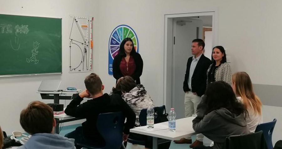
Conversatorio sobre Cuba con jóvenes estudiantes

Como parte de las actividades que viene desarrollando la Embajada, el consejero de Turismo, Osnier Fonseca, visitó el Liceo Educativo General Privado (GKJ), en la ciudad de Lozd, donde se imparte Turismo, como asignatura opcional a elección del alumnado, así como idioma español. En las aulas, se habló sobre Cuba, su historia, resaltando sus ciudades y sus costumbres, sus playas, propiciando además un intercambio abierto con los estudiantes.

“Visitan funcionarios de la Embajada de Cuba la Sociedad Educativa TE VIZIA durante las celebraciones por el Día de La Hispanidad”

El pasado 12 de octubre, la II Secretaria de la Embajada de Cuba en Polonia Olivia Bosque González acompañada por Ricardo Javier Sanz Pérez visitaron el Centro Escolar Sociedad Educativa TE VIZIA para disfrutar de las actividades preparadas en el marco de los festejos organizados por el centro y su catedra de Español durante el Día de la Hispanidad o Día del Idioma Español, como también se le identifica.

Asiste Encargada de Negocios a.i. de la República de Cuba en Polonia a reunión con políticos de izquierda en el Parlamento Polaco

Este lunes, la Encargada de Negocios a.i. de la República de Cuba en Polonia, Olivia Bosque González, asistió a la reunión sostenida con el Club Parlamentario de Izquierda dentro de la Cámara Baja del Parlamento Polaco (Sejm). Durante el encuentro, al que fue invitado el cuerpo diplomático acreditado en Polonia, se presentó el programa y los desafíos de la Izquierda polaca en el período 2019-2023 y se abordaron otros temas como la situación política actual del país, la crisis en Ucrania y la lucha contra la pandemia.

Uroczyste otwarcie wystawy zdjęć – „Kuba – perła Antyli”

Piękny występ zespołu TropiCuba, odwiedziny Pani Konsul Republiki Kuby w Polsce Olivii Bosque oraz Pana Osniera Fonseki, no i otwarcie wystawy zdjęć autorstwa Ryszarda Sobolewskiego. Tak można streścić naszą piątkową uroczystość. Mimo, że głównym punktem było otwarcie wystawy, to jednak występ kubańskiego zespołu muzyczno-tanecznego przyciągnął najwięcej uwagi.

Anniversary of the Revolution. Republic of Cuba

Cuba, country of the West Indies, the largest single island of the archipelago, and one of the more-influential states of the Caribbean region. The domain of the Arawakan-speaking Taino, who had displaced even earlier inhabitants, Cuba was claimed by Christopher Columbus for Spain in 1492. It became the Spanish empire’s most-important source of raw sugar in the 18th century and later earned the sobriquet “Pearl of the Antilles.” Though Spain had to fight several difficult and costly campaigns against independence movements, it retained rule of Cuba until 1898, when it was defeated by the United States and Cuban forces in the Spanish-American War. Cuba soon gained formal independence, though it remained overshadowed by the nearby United States. On New Year’s Day, 1959, revolutionary forces led by Fidel Castro overthrew the government of dictator Fulgencio Batista. Two years later Castro proclaimed the Marxist-Leninist nature of the revolution. Cuba became economically isolated from its northern neighbour as it developed close links to the Soviet Union. However, the collapse of the Soviet Union in the early 1990s isolated Cuba still further, bringing on what Cubans euphemistically call the período especial (“special period”), a time of widespread shortages and financial uncertainty. By the early 21st century, Cuba had loosened some of its more-restrictive economic and social policies, but the United States continued its decades-long economic embargo against the Castro regime, though the December 2014 announcement of the resumption of diplomatic relations between the two countries held promise of the embargo’s removal. Life in contemporary Cuba is thus challenging, given the limited access to food, transportation, electrical power, and other necessities. Even so, many Cubans show a fierce pride in their revolutionary society, the only one of its kind in Latin America. The protagonist of anthropologist Miguel Barnet’s novel Canción de Rachel (1969; Rachel’s Song, 1991) describes it thus: This island is something special. The strangest, most tragic things have happened here. And it will always be that way. The earth, like humankind, has its destiny. And Cuba’s is a mysterious destiny. Cuba is a multicultural, largely urban nation, although it has only one major city: Havana (La Habana), the capital and commercial hub of the country, on the northwestern coast. Handsome if rather run-down, Havana has a scenic waterfront and is surrounded by fine beaches, an attraction for increasing numbers of visitors from abroad. Cuba’s other cities—including Santiago, Camagüey, Holguín, and, especially, Trinidad—offer a rich legacy of colonial Spanish architecture to complement contemporary buildings. Land Cuba is situated just south of the Tropic of Cancer at the intersection of the Atlantic Ocean (north and east), the Gulf of Mexico (west), and the Caribbean Sea (south). Haiti, the nearest neighbouring country, is 48 miles (77 km) to the east, across the Windward Passage; Jamaica is 87 miles (140 km) to the south; the Bahamas archipelago extends to within 50 miles (80 km) of the northern coast; and the United States is about 90 miles (150 km) to the north across the Straits of Florida. The country comprises an archipelago of about 1,600 islands, islets, and cays with a combined area three-fourths as large as the U.S. state of Florida. The islands form an important segment of the Antilles (West Indies) island chain, which continues east and then south in a great arc enclosing the Caribbean Sea. The island of Cuba itself is by far the largest in the chain and constitutes one of the four islands of the Greater Antilles. In general, the island runs from northwest to southeast and is long and narrow—777 miles (1,250 km) long and 119 miles (191 km) across at its widest and 19 miles (31 km) at its narrowest point. Relief Groups of mountains and hills cover about one-fourth of the island of Cuba. The most rugged range is the Sierra Maestra, which stretches approximately 150 miles (240 km) along the southeastern coast and reaches the island’s highest elevations—6,476 feet (1,974 metres) at Turquino Peak and 5,676 feet (1,730 metres) at Bayamesa Peak. Near the centre of the island are the Santa Clara Highlands, the Sierra de Escambray (Guamuhaya), and the Sierra de Trinidad. The Cordillera de Guaniguanico in the far west stretches from southwest to northeast for 110 miles (180 km) and comprises the Sierra de los Órganos and the Sierra del Rosario, the latter attaining 2,270 feet (692 metres) at Guajaibón Peak. Much of central-western Cuba is punctuated by spectacularly shaped, vegetation-clad hillocks called mogotes. Serpentine highlands distinguish northern and central La Habana and Matanzas provinces, as well as the central parts of Camagüey and Las Tunas. The plains covering about two-thirds of the main island have been used extensively for sugarcane and tobacco cultivation and livestock raising. The coastal basins of Santiago de Cuba and Guantánamo and the extensive Cauto River valley lie in the southeast. The Cauto lowland adjoins a series of coastal plains that continue across the island from east to west, including the Southern Plain, Júcaro-Morón Plain, Zapata Peninsula (Zapata Swamp), Southern Karst and Colón Plain, and Southern Alluvial Plain. Cuba’s most extensive swamps cover the Zapata Peninsula and surround the Bay of Pigs (Bahía de Cochinos). The Las Villas Plain of the North, Las Villas Plain of the Northeast, and Northern Plain stretch across much of the opposite coast. Cuba’s approximately 3,570 miles (5,745 km) of irregular, picturesque coastline are characterized by many bays, sandy beaches, mangrove swamps, coral reefs, and rugged cliffs. There are also some spectacular caverns in the interior, notably the 16-mile- (26-km-) long Cave of Santo Tomás in the Sierra Quemado of western Cuba. The main island is surrounded by a submerged platform covering an additional 30,000 square miles (78,000 square km). Among the extensive cays and archipelagoes ringing the main island are Los Colorados, to the northwest; Sabana and Camagüey, both off the north-central coast; the Jardines de la Reina (“Queen’s Gardens”), near the south-central coast; and Canarreos, near the southwest coast. Juventud Island (Isla de la Juventud; “Isle of Youth”), formerly called Pinos Island (Isla de los Pinos; “Isle of Pines”), is the second largest of the Cuban islands, covering 850 square miles (2,200 square km). It is technically a part of the Canarreos Archipelago. Hills, dotted with groves of pine and palm, characterize much of the island’s northwest and southeast. Sand and clay plains cover parts of the north, a gravel bed takes up most of the southern part of the island, and bogs dominate the coasts and sparsely inhabited interior. Drainage Cuban rivers are generally short, with meagre flow; of the nearly 600 rivers and streams, two-fifths discharge to the north, the remainder to the south. The Zapata Peninsula is the most extensive of Cuba’s many coastal wetlands. The main island’s heaviest precipitation and largest rivers are in the southeast, where the Cauto, at 230 miles (370 km) the country’s longest river, lies between the Sierra Maestra and the smaller Sierra del Cristal. The Cauto and its tributaries, notably the Salado, drain the Sierra Maestra and lesser uplands in the provinces of Holguín and Las Tunas. Other rivers in this region include the Guantánamo, Sagua de Tánamo, Toa, and Mayarí. To the west the most important southward-flowing rivers are the Sevilla, Najasa, San Pedro, Jatibonico del Sur, Zaza, Agabama, Arimao, Hondo, and Cuyaguateje. Northward-flowing rivers include the Saramaguacán, Caonao, Sagua la Grande, and La Palma. Cuban lakes are small and more properly classified as freshwater or saltwater lagoons. The latter include Leche (“Milk”) Lagoon, which has a surface area of 26 square miles (67 square km). It is technically a sound because several natural channels connect it to the Atlantic Ocean. Sea movements generate disturbances in the calcium carbonate deposits at the bottom of the lake to produce the milky appearance of its waters. Soils of Cuba The complicated Cuban topography and geology have produced at least 13 distinct groups of soils, the majority of which are fertile and cultivated throughout the year. Highly fertile red limestone soil extends from west of Havana to near Cienfuegos on the southern coast and lies in extensive patches in western Camagüey province, providing the basis for Cuba’s main agricultural output. Another area of fertile soil is north of Cienfuegos between the Sierra de Sancti Spíritus and the Caribbean coast. Camagüey province and the Guantánamo basin have some arable land, although of lower fertility. Areas of sandy soil in Pinar del Río, Villa Clara, and portions of Ciego de Ávila and Camagüey provinces cannot hold moisture and are marginally fertile, as are the soils of the mangrove-dotted coastal swamps and cays. Climate Cuba lies in the tropics. Because it is located on the southwestern periphery of the North Atlantic high atmospheric pressure zone, its climate is influenced by the northeast trade winds in winter and by east-northeast winds in summer. The warm currents that form the Gulf Stream have a moderating influence along the coasts. The annual mean temperature is 79 °F (26 °C), with little variation between January, the coolest month, at 73 °F (23 °C) and August, the warmest month, at 82 °F (28 °C). The November–April dry season abruptly changes to the May–October rainy season. Annual precipitation averages 54 inches (1,380 mm). From June to November the country is often exposed to hurricanes, whose strong winds and heavy rains can cause widespread damage and suffering. More …. Source:  https://www.britannica.com/place/Cuba

Organizacje i instytucje kultury